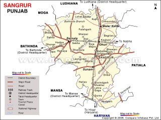
Sangrur District
Monday, November 27, 2006
Thursday, November 09, 2006
Sangrur District
Hello all my Friends from Sangrur.
My name is Suchet Vatish, a blogger from sangrur district. After completing my early education in sangrur, i have done my Graduation from PTU. And right now i am working as a webmaster of various websites.
About the origin of this district as i know, The district of Sangrur was formed in 1948. The name of the district from its headquarters, Sangrur, said to be have founded by one Sanghu, a Jat, about 400 years back.The Sangrur District as of today comprises parts of a few erstwhile distinct administrative units, the Philkian States if Jind, Nabha and Patiala: the Mohammadan State of Malerkotla; and some parts of then district of Ludhiana. It is interesting to note that Sangrur itself was earlier a part of Nabha State. History of the district is, therefore, complicated, although it is traceable through its various components. The district ranks 3th in the State after Firozpur, Faridkot districts in terms of area.
There are four main gates in Sangrur named as
Nabha Gate
Dhuri Gate
Patiala Gate
Sunami Gate
The Population of theis district is app. 2000173


